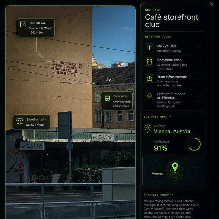
Image geolocation works best when you stop looking for a magic clue and start building an evidence inventory. A single visual clue can point you in a direction, but a reliable result usually comes from several details agreeing: text, road design, architecture, terrain and map geometry.
This checklist is meant to be used before you commit to a location. Write down the visible evidence, classify its strength, then use the stronger clues to search and verify candidates. It pairs naturally with the broader guide on how to find where a photo was taken.
| Clue | Best use | Main risk |
|---|---|---|
| Readable text | Searchable names, signs and official wording | Tourist and multilingual areas can mislead |
| Road design | Country, city and street-level verification | Similar standards across regions |
| Architecture | Regional narrowing and neighborhood type | Shared styles and replicas |
| Terrain | Eliminating impossible candidates | Often too broad alone |
| Map geometry | Final viewpoint verification | Requires a candidate first |
1. Read text before interpreting style
01Text is usually the highest-value clue
Street names, shop signs, public notices, road signs, posters, transit labels and municipal wording can produce exact search terms. Search unusual phrases in quotes and test spelling variations if OCR is uncertain.
2. Check road markings and traffic direction
02Road infrastructure narrows candidates quickly
Lane direction, crosswalk style, bollards, traffic lights, curb shape, cycle lanes and road signs can point to a country or city. Public transport clues such as tram tracks, bus-stop design and route colors can be especially useful.
3. Use architecture as supporting evidence
03Buildings help, but rarely prove the answer alone
Roof shapes, balconies, facade colors, shutters, wall materials and street furniture can narrow a region. Treat architecture as support, not proof. Historic centers and tourist districts can look similar across countries.
4. Compare vehicles and plates responsibly
04Vehicles can reveal regional patterns
License plate shape, taxi colors, bus models and emergency vehicle markings can help identify a place. Avoid using private identifiers for targeting people. Focus on broad format and public-service design.
5. Read terrain, vegetation and climate cautiously
05Natural clues are good at eliminating wrong places
Mountains, coastlines, tree species, soil color, snow, dry scrubland or tropical vegetation can rule candidates in or out. They are most reliable when paired with human-made clues such as roads, signs or buildings.
6. Look for unique geometry
06The final match often comes from spatial relationships
A building next to a road bend, a tower behind a roofline, a bridge angle over water or a mountain outline behind a street can verify a candidate. Compare relative positions, not only individual objects.
Common mistakes
- Assuming a language equals a country.
- Overtrusting architecture from a tourist district.
- Using one weak clue as proof.
- Ignoring image age and changed storefronts.
- Skipping map verification after finding a plausible candidate.
FAQ
What visual clue is strongest?
Readable local text, unique landmarks and map geometry are usually strongest because they can be searched and verified independently.
Can vegetation identify a country?
Usually not by itself. It can eliminate impossible places or support a climate region, but it should be paired with stronger evidence.
Do screenshots still contain visual clues?
Yes. Screenshots usually lose metadata, but visible text, roads, buildings and map context can still support geolocation.
Try the checklist on one image.
Upload a photo and let LoadQ extract visible clues, OCR text and location candidates.